Genealogical Implications, Cemetery Disruptions
(a talk by Jane Simpson)
January 22, 2022
For generations, and indeed for nearly two centuries of settlement here in Ontario, it was understood and accepted that society, its systems, and its processes would move along much as they always had. Births, marriages, and deaths would take place, and the traditions of those stages would continue, largely centered around places of worship, often Christianity, but also other faiths. And it was generally believed that burial places, often on land adjacent to worship buildings, were sacred ground, at least for a ‘while’, as implied by the ‘term’ ‘perpetual care’. The concept of burials being sacred across cultures is thousands of years old.
Alas, with western style population and business growth in our towns, cities, and beside busy roadways, along come various needs for different land uses including housing ‘infill’, road widening or building, expansion of resources requiring a larger building footprint, or more parking space. In addition, the loss of burial markers by ‘hooligans’ or as pathway stones, and often the total disappearance of unkempt burial places, meant that some of these pieces of land have lost their reverence in the eyes of the community. Jane Simpson has studied some examples with an eye to what is lost, and what is gained when a burial site is lost, dug up, studied by archaeologists, relocated, or repurposed.
Jane Simpson, presented to the Kingston and District Branch UELAC her talk titled: Genealogical Implications. Cemetery Disruptions.
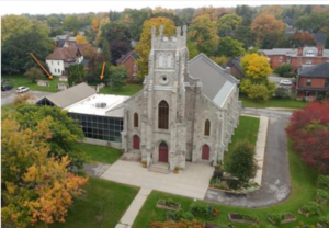
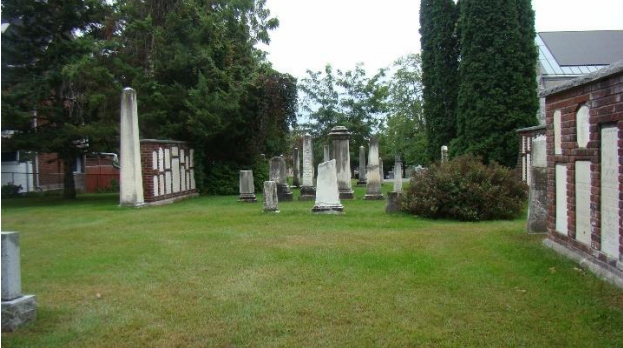
Jane took us to the site of Saint Thomas’ Anglican Church on ‘East Hill’ in Belleville, Ontario, a traditional Gothic Revival style church. The first red brick church building was completed in 1821 for some of Belleville’s 150 residents and was called homely by Susannah Moodie. A stone church replaced it in 1858 and after an 1876 fire, it ‘again’ reopened in 1879. This area of Belleville, high and away from the annual spring floods of the Moira River, grew in the mid to late 1800’s with many grand residences of the Upper Class including Glanmore Historic Site being not far away.
![]() [above: 1930 – 40’s St. Thomas’ Anglican Church Postcard. The BLUE arrow points to the old Cemetery]
[above: 1930 – 40’s St. Thomas’ Anglican Church Postcard. The BLUE arrow points to the old Cemetery]
![]() [at right:1942 Belleville Fire Insurance map of the area, RED arrow points to the blue arched word ‘cemetery’.]
[at right:1942 Belleville Fire Insurance map of the area, RED arrow points to the blue arched word ‘cemetery’.]
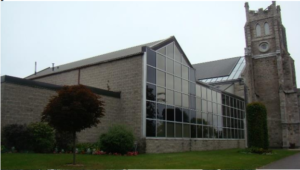
A 1975 fire required a nearly-total rebuild of the church, providing the opportunity to design a modern adjacent hall for events such as Sunday School, rather than one across the busy and dangerous Bridge Street.
St. Thomas’ Church cemetery was the anecdotal burial location of one of Jane’s ancestors but in searches, there was no burial marker to be found. Being a military man, and a Captain, he likely, or at least possibly, was buried in his uniform. Something more about this later.
During the congregation-initiated archaeology required for the building of the new glassfronted hall, they discovered that instead of 80 burials there were something like 607 or more, and a later discovery by Gerry Boyce indicated that there were more than 1500 burials. This resulted in delays, the need for grants, and McMaster University became involved. The new hall finally opened in 1990.
The Archaeologist, Professor Dr. McKillop of Louisiana State University, continued, as of 2015, to lecture about coffin handles and other found artifacts, using the St. Thomas situation as an example of what can happen in a cemetery disruption, yet, as far as is known, there has not been a presentation by her or anyone else in Belleville.
St. Thomas Church website describes the archaeologist-led burial-ground transformation resulting situation as follows:
 “The remains of the deceased were interred in a common grave, each with their own packet of bones, in the north-east part of the cemetery. The tombstones were assembled into cairns; some were repositioned by the northeast wall of the church. The Parish Hall,
 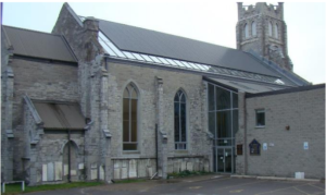 dedicated in June 1990, and the parking lot, were built on the cleared part of the cemetery.”
The added orange arrows [in the aerial image above] point to the ‘cairns’ with inset stones in the back left by the parking lot and behind the glass-fronted addition.
 Others were placed in the lower rebuilt walls shown below, and note that land to the right and in front of the church is a steep hill going down to busy main roadways in both directions, and not available for much use other than the gardens you can see.
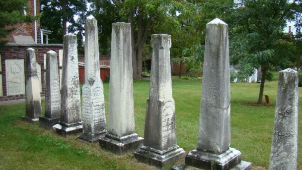
Additional Resources about St. Thomas Cemetery:
Some references and images here are from the online blog pages by another family looking for their ancestors. Names include BROWN and VANCE. [One of their BROWN family members, a Margaret ORR, connects to Mathias ROSE UE through the Nathaniel ORR lighthouse-keeper family of Snake Island and Wolfe Island.] https://boardmanbrown.wordpress.com/2014/09/28/ontario-wanderings-st-thomas-church-cemetery/
See also: St. Thomas’: http://www.findagrave.com/cgi-bin/fg.cgi?page=cr&CRid=2321029
http://www.torontoghosts.org/index.php/the-province-of-ontario/eastern/389-belleville-st-thomass-churchcemetery- (Not for all tastes since it has a ghost-finding theme for this place and others.)
 In other research about her ancestors, Jane discovered three disturbed New Rochelle, New York burial grounds including a 1707 Huguenot ancestral burial ground in Westchester County, New York State with over 400 burials including her Gerow / Giraud ancestors. These disturbed long ago initially by being bisected by a mid-1800’s railway, later by a roadway then more cemetery land was overbuilt in 1956 with the New England thruway, now a multilane highway. Many burials under the umbrella of Trinity Saint Paul’s Episcopal were relocated after litigation. It certainly is no longer a peaceful place of loving reverent reflection. Many details are at: https://www.findagrave.com/cemetery/2621203/trinity-episcopal-church-cemetery
Most images below are from: https://nyheritage.org/collections/historic-photographs-newrochelle
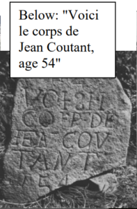
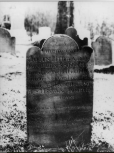 [at left: An 1807 stone
among many very old similar shaped ones:
“In memory of John Hibbard, son of Billy S. Sibbel Hibbard, who
died in full confidence of the love of God on the 1st day of Dec. 1807, aged 18 years, 4 months & 2 days]
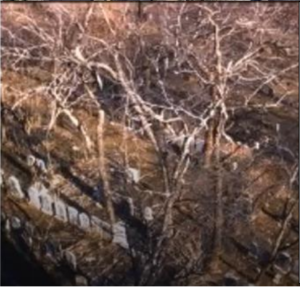
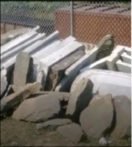 [below left and right: Markers before and after disruption].
Burial markers and stones tell us more than just the inscribed names and dates. They can tell us about the financial options available for burial of our ancestors on specific land.
They can suggest connections to investigate with likely relatives and possible neighbours buried nearby. Markers created from a certain type of stone quarried in certain places and using certain stone shapes and markings can all enhance the understanding of who they were. After disturbances, much of that could be lost.
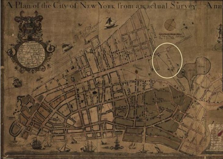
[This 1754 map is called the “Maerschalk Map Collect Pond Negros Burial Ground 1754”. Notice the Freshwater ‘pond’ and the “Negro burial ground” outside the northern palisades of that era where Broadway ended at that time. The map is from: https://www.nps.gov/afbg/learn/historyculture/index.htm]
 [right: This location is now 290 Broadway.]
Research in 1991 in Manhattan prior to the construction of a 34-storey building at 290 Broadway Avenue uncovered a 6 to 8 acre mid 1700’s to 1812 burial ground, with 12,000 to 20,000 intact African or African-American burials, more than 30 feet below modern street level.
This became the most important historical archaeological project of this type to date in the U.S.A.. “African Burial Ground is the oldest and largest known excavated burial ground in North America for both free and enslaved Africans. It protects the historic role slavery played in building New York.” (image below right) https://www.nps.gov/afbg/index.htm
This next link is to a detailed 371 page document about the discoveries and genetics related to those African-American burials. https://www.nps.gov/afbg/learn/historyculture/upload/downVol1-Part1-The-Skeletal-Biology-ofthe-NYAGB.pdf
Near Fredericton, New Brunswick the segregated Kingsclear Kilburn Cemetery had two areas; one for black burials: the Kingsclear Early Negro Cemetery, and the other on higher land for white burials. All were endangered by the planned higher water level behind the Mactaquac Dam, built in 1964. Homes, churches and all in the path of the future high-water area were cleared and burnt.
The graves of black individuals were at lower elevations and between the railway line and the St. John’s River. These were burials that may have had wooden markers and most remains were in shrouds or blankets, not caskets, putting them at even more risk for loss. The mitigation strategy, accepted prior to the dam being filled, was to cover the some of the black graves with gravel but not all as per one document. In contrast, the white burials and monuments were removed to higher ground and a plaque was erected to early white settlers. More recently a granite monument was installed dedicated to families of the Kingsclear Early Negro Cemetery, memorializing those who were not reburied, and often not gravel covered, although the proposed design with full names and dates was scrapped in favour of a less detailed one. A detailed replacement has been requested and approved. The below article shows all those details.
Certainly, this is an example of significant loss. The following CBC article present details and photos. https://www.cbc.ca/news/canada/new-brunswick/mactaquac-dam-cemetery1.6085733
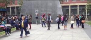
Many Kingston residents are familiar with the Lower Burial Ground (1783 – 1840) and issues with the St. Paul’s Church and hall buildings covering burials, along with recent passive Archaeology (sweeping only – no digging) having been done under the hall. https://www.lowerburialground.ca/burials/
 And we may be familiar with what was ‘The Upper Burial Ground’ that was used more when the Lower one was full, with some burials from the Lower one being moved to the Upper one. Tales of children finding bones in what is now ‘Skeleton Park’ or ‘McBurney Park’ while playing are common.
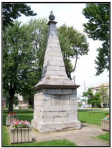 In 1816 it was a Garrison Burying Ground, and by 1825 called the Upper or Common Burying Ground. By 1850, it too was at capacity and closed in 1864. It was converted to a park in 1893 after having been neglected and becoming a disgrace. Many markers and burials, several layers deep, were moved to St Mary’s and Cataraqui Cemeteries. Due to the limestone bedrock and the water in the area, the decomposition was incomplete, and over the years, many bones protruded up, or at least were found with little digging needed. It was also called Frontenac Park. https://www.lowerburialground.ca/history/other-burial-places-in-kingston/
In this 1893 photo [above] we see the Barclay Monument standing tall, and it remains to this day as a reminder of the earlier burials for which there are largely no records except for those reburials that were moved. Archaeology has been done ensuring that additional disturbance respects the burials. This site has more about local burial areas, including ones that seem to be now covered by homes on private property.
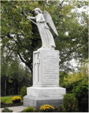 The KGH Irish Typhoid burial site may remain unknown to many. From this below website, in 1847..
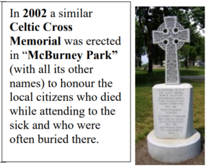
“Several thousand peasants disembarked in Kingston looking for a better life although most of them were sick and dying from Typhus. Approximately 1,400 people died including a number of the denizens of Kingston who fell ill while tending to the sick. The immigrants were buried in a common grave, several layers deep, south of the grounds of [then] Kingston General Hospital.”
In 1894, The Angel of Mercy statue with its Gaelic, and English dedication was installed in front of the Watkins Wing.
“In 1966, to allow for expansion of Kingston General, the (some) buried remains, and the Angel of Mercy monument, were relocated to the north-west corner of St. Mary’s Roman Catholic Cemetery at Kirkpatrick and Division streets.” (Some say dozens or more remain.)
https://wordsonstone.wordpress.com/tag/angel-of-mercy/
So, now Jane takes us back to the St. Thomas burial ground. Her ancestor Charles MacDonald’s burial stone did not turn up in the removal of stones, but it was said that ‘hooligans’ tossed away some stones during the work.
But after more ‘digging’, it was discovered that he was indeed listed in the burial records ‘at’ St. George’s likely with the Ontario District Diocese Anglican Records, with the details showing that he was indeed buried there. Nor was it initially not known if any of his uniform buttons were found, or at least such information was not available to the public. The artifacts remain with McMaster University rather than in Belleville or at the church, including 500 buttons, but supposedly they were not separated by burial.
Later, Dr McKillop was approached and did confirm that there were no buttons recorded with the artifacts from the burial of #473, Jane’s ancestor.
Additional photos and details are in Gerry Boyce’s book: Belleville: A Popular History and many pages starting at p 232 are at: https://www.google.ca/books/edition/Belleville/WmHRKelpRsC?hl=en&gbpv=1&dq=Gerry+Boyce+Belleville&printsec=frontcover
 With so many burial grounds in different regions lost to progress with the expansion of roads, creation of new buildings or additions, and hydro power dams, we may wonder how to deal with older burial grounds. If it has been more than 100 years since the last interment, are we free and clear to disturb these burials grounds? How should these remains be managed?
 Laws about this did not always exist as clearly as now, but for Ontario this 2002 document, and some for previous years, indicate that if a cemetery is closed that ALL remains are to be relocated. Section 88 (7) b) i) . https://www.ontario.ca/laws/statute/02f33#BK105
Other lessons learned regardless of ‘noble intent’:
- Community Projects and Monuments help families and communities heal
- Academic and Government intervention can bring much Red-Tape and divisive situations to the project
- ‘Project – creep’ can happen in this case of St. Thomas Cemetery going from 60 burials to over 1,500 !
- Scientific findings increase knowledge including information about the higher rate of women having Tuberculosis, and a high number of broken bones due to physical labour.
But we still may wonder what ‘Perpetual Care” means.
Jane offered thanks to Gerry Boyce of Belleville and the Belleville and Hastings Community Archives among others. https://www.cabhc.ca/en/index.aspx
Jane’s Book: Charles MacDonald: Soldier, Settler, Sinner is available at: https://www.turtlepointbooks.com/ and Info@turtlebooks.com (It shows up at Indigo, but that is no longer valid.) Charles was an ancestor of the artist Manly MacDonald, well known in the region!