
Early surveying of the lands pre Loyalist settlements
(a talk by Mr. Nigel Day)
September 26, 2015
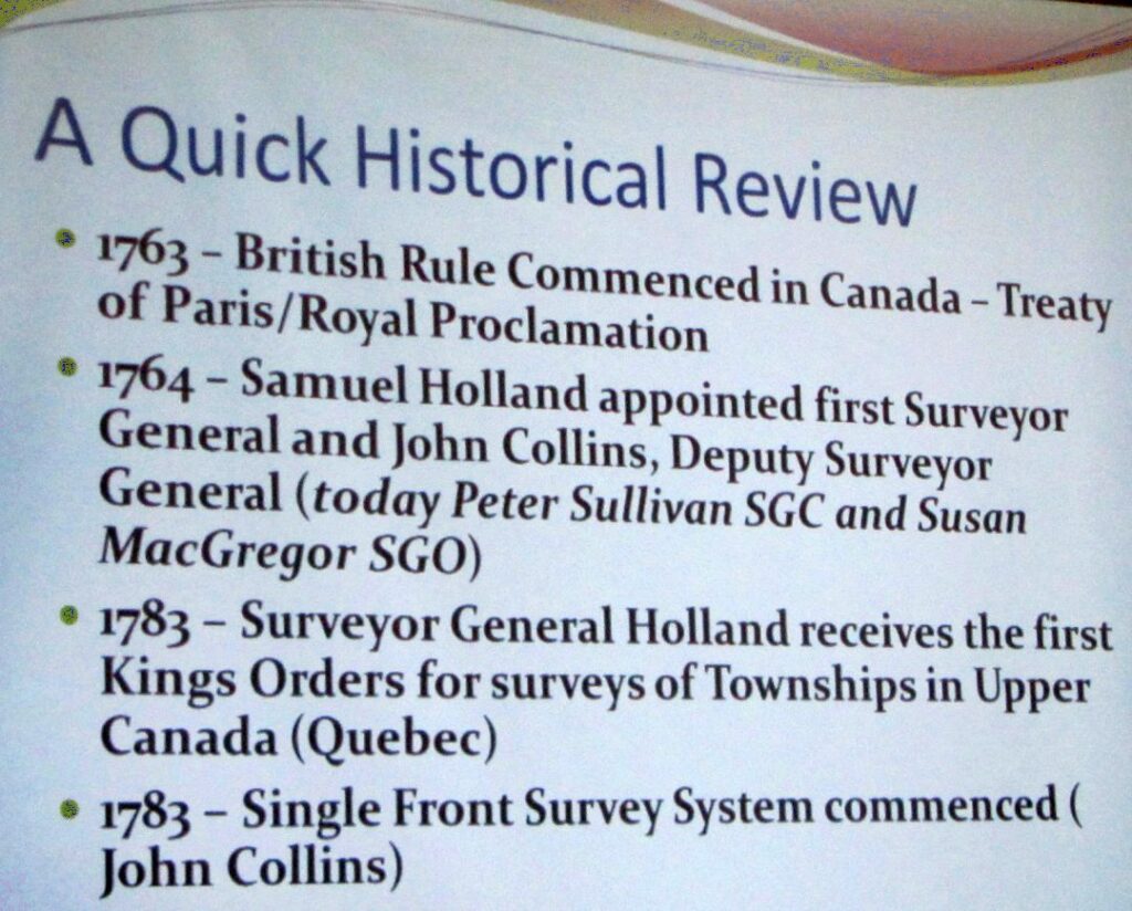
 Our speaker was Mr. Nigel Day, OLS, OLIP, Head of the Geomatics Section at the Ministry of Transportation, Eastern Region, who gave a most interesting talk about early surveying of the lands pre Loyalist settlements.
Most of us have had difficulty relating the fact that an ancestor had land on, say, Lot 5, Concession 6 to the actual land: where exactly was that lot? Nigel explained how surveying and other geomatics skills can more easily locate this information today. For some background, Nigel first showed us how his department was able to confirm the location of a portion of the Addington Road near Kaladar, opened in 1861 as a colonization road — it was a Road that would have helped settlers get onto the land. It was most probably used by horse or horse and trap and likely fell into disuse once the motor car came along. By comparing the surveyors’ notes from the time with current aerial photographs, they could pick out where the remains of the early road were. When searching on the ground in the area, remains of the road bed became evident, along with stone walls and even steps. He showed a rusted horseshoe and an empty glass cod liver oil bottle found along the faint vestiges of the road as well as photos of what was found.
The law states that what matters regarding boundaries is typically where the first markers are placed during the original survey. Loosely, after the first marks are placed and persons occupy the land, the original monuments override any erroneous distances or directions that were supposed to be laid out by the early surveyors. Distances and directions could vary due to site conditions, magnetic anomalies, human error and other factors. The first surveyors were issued instructions of where to commence and how to proceed. Sizes of lots were dictated and lots were laid out according to those instructions. The presentation outlined some research to date (admittedly far from complete) pulling together early maps, reports, notes and modern aerial photography to show what the original survey looked like and which were the original roads in the area. Additionally, the idea was to present some interesting findings and some items that could be considered unusual and where further research is needed simply to understand how this first township was surveyed and settled.
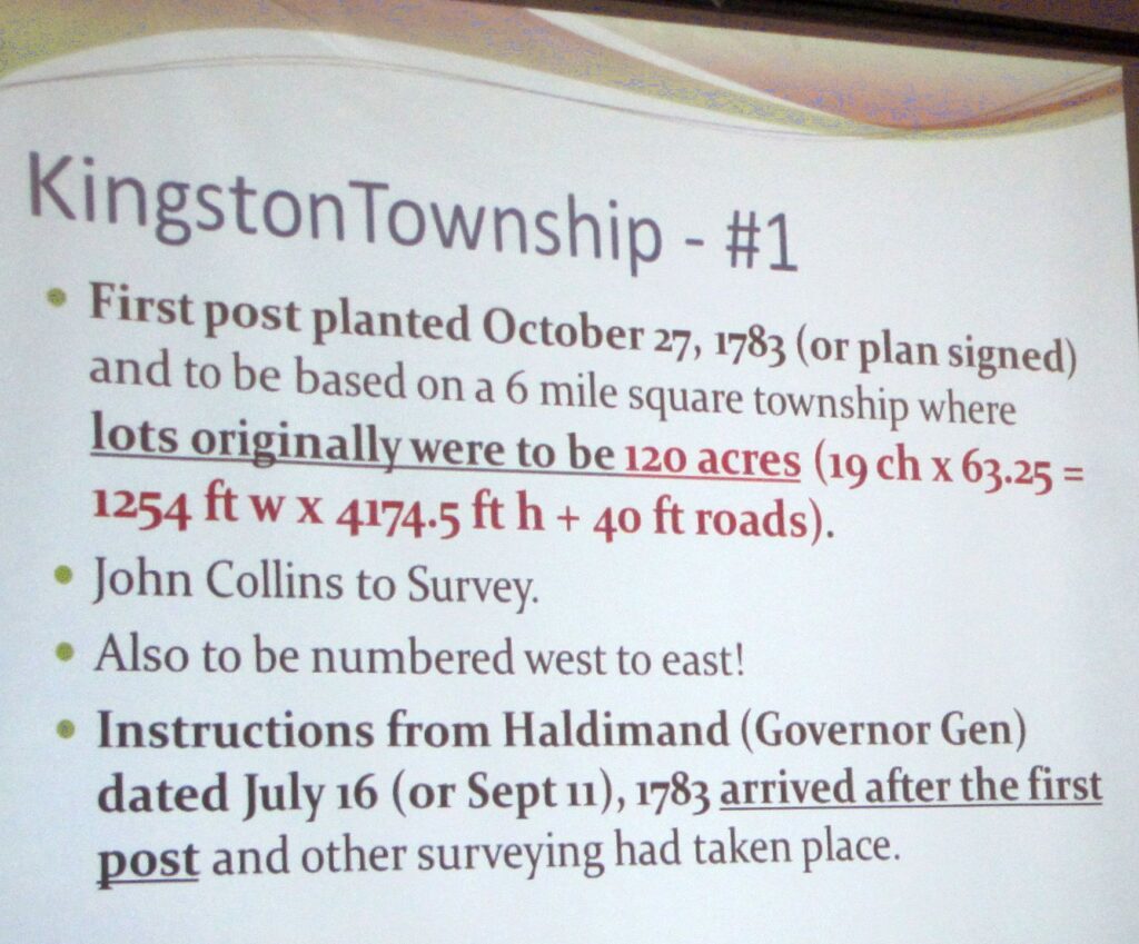
Kingston Township, known as #1, was the first township survey in Upper Canada. A question was posed as to whether it might not be the first fully completed survey, because of some of the discrepancies he has noted. Even though one copy of one set of original instructions exists, the resulting lot system was altered in comparison to those expectations. There was quite probably a different set of instructions also issued which have not yet been located. Additionally, the original field notes are missing. The lot size given in the instructions to the surveyors by John Collins changed during the first year. Nigel showed a copy of a document which has the date of 17 May 1782 at the end above John Collins’ signature, but has Sept. 11, 1783
on the cover page which adds to the complexity of clearly understanding how the survey and settlement proceeded.
The first lots surveyed or laid out were possibly/probably 120 acres due to the request in the initial instructions (a copy of which we have), but that was going to cause complications in the allocation to Loyalists: grants were made in increments of 50 acres for privates, 200 for NCOs, and 500 for officers. Further instructions must have been received altering the required lot sizes to 200 acres (but these instructions have not yet been acquired). (And that explains why some Loyalists received 1/4 of a lot!). Somewhere in the initial year either before or after the full original survey (again, the original field notes are missing), the lot sizes were significantly altered along with where the roads or road allowances were originally established.
In further analyzing early information, one discovers an unusual mix of measurements with ties to the east and west corners of the township along Lake Ontario. These tie measurements on the original plan are measured in perches rather than the rest of the plan being in chains. A perch was a holdover from the old French system of land measurement, and equaled 16.5 feet and the mix of perches and chains is a bit unusual. The chain, by comparison, was 66 feet in length — which was often also the width of the original road allowances (in Kingston Twp they were 40 feet originally).
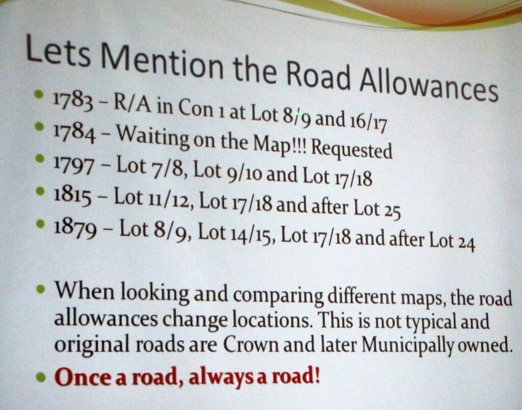
Digging more deeply into the historical information and looking at maps from progressive years, one can notice that road allowances seem to change in location and/or lot numbering actually changes which is quite unusual. Maps could have human errors in their creation, however certain concessions have lot numbers which do not align and can specifically be noticed in going north from Lot 25, which in concessions further up changes to lot 24. This can happen due to measurement anomalies, but again the alignment of the lots here is very unusual.
Other questions arise:
* Why does Division Street (running southerly) not continue straight and right to the lake? The original road allocation shown on some of the early maps should have it continue straight down (would be near the corner of Barrie and King), but it swung east along what is now West Street.
* King Street showed great variation even when first surveyed. Part of the problem, Nigel explained, is that magnetic compasses have a significant deviation along Kingston’s waterfront and as far out in the lake as south of Wolfe Island, due to a large underground deposit of iron. So when the survey crews laid out their chains in 1783 after driving in the first markers, they were possibly not heading in the directions they thought (certainly at the south east end of the township).
* He has also found some markers which do not appear to have been moved, but are in an unexpected place. Along the western boundary of Kingston Township, a marker labelled “C1” which possibly should have been at the northwest corner of Concession 1, Lot 1 is in fact short of the mark from a distance perspective. Does C1 mean 100 chains or Concession 1 and why is there a stone monument at this position? It is unusual since there was either a monument originally at 63.25 chains (120 acre lot) or 105.27 chains (but would be in the bay – 200 acre lot) or a witness to that point. Without the original notes we cannot tell with certainty why the post (stone marker) is planted there. It can be found northwest of the parking lot at Lemoine Point: take the path northwest and just past the lone tree on the left, go up the small trail to a small power line and turn right at the line and it will be ahead on the path.
Unfortunately the surveyors’ original notes and reports, and some maps, for Kingston Township are missing. They may be in the British Archives, but attempts to request a search for them have been unsuccessful. (The notes and reports for the survey of Pittsburgh Township are at Queen’s Archives.)
This certainly raised some interesting questions about the vagaries of Kingston Township’s original layout. Anne Redish pointed out that Michael Grass was first given land that would now include City Park and the Court House, but did not want that and eventually obtained land further west, around the present airport. Perhaps he and other prominent Loyalists persuaded the surveyors to alter the layout of certain properties? No one will ever know, but Nigel Day has found it an interesting puzzle, and plans to continue researching it.
Photos by Nancy Cutway. Thanks to Nigel Day for permission to photograph his slides, and for his careful review of my non-scientific interpretation of surveying terms.